

Perched on the northern cliffs of Maui, overlooking the pounding waves below, the Ohai Trail loop is an incredible and easy hike. The trail is only 1.2 miles long, but is one of the best hiking trails in Maui with sweeping views of the dramatic coastline as it travels over rolling hills. The best way to do this hike is if you are driving the north western loop around Maui. You can find many amazing places to stop and walk the coast, but this trail was one of our favorites.
Below you can find details of hiking the Ohai Trail including how to get to the Ohai Trail, what to expect on the trail and a hiking map.
I’ve spent decades exploring family adventures, epic hikes, and National Parks across the world. For more inspiration, check out my National Parks Page or see some of my favorite destinations to plan your next adventure and make sure to join my weekly newsletter.

Quick Look at the Ohai Trail, Maui
Distance:1.2 miles
Elevation Gain: 175 feet
Difficulty: Easy
The Ohai Loop Trail starts at a small parking lot and can be hiked in either a clockwise or counterclockwise direction. The trail is easy walking and mostly flat with a few rocks. The entire trail is easy to follow as the trail passes through mostly low vegetation. Hiking boots are best, but you can also hike the Ohai Trail in sneakers or hiking sandals. While we didn’t have any mud, several reviews mentioned mud, so if it rained recently, you may want to consider waterproof shoes.
The trail passes near and across several interesting rock features as it passes along the edge of the cliff. Use common caution near the edge of the trail. As the trail loops back around you will pass through a thicker forested area. If you don’t have time for the whole hike, you can walk the short paved section to the overlook right near the parking lot.
You can see complete details of this hike at the bottom of this article.
To see reviews of recent of the hiking trail, visit the hike on All Trails.

Things to Know About Hiking the Ohai Loop Trail
How to Get to the Ohai Trail
The Ohai Trail is located directly on hwy 30 in northwest Maui. The best way to visit this hike is by driving the loop that follows the coastline. It is only 6 minutes from the Nakalele Blowhole, making these two good hikes to do together and is also very close to the Olivine Pools (another short hike). Below are a few driving distances to help you plan your visit. It’s important to note that some of the roads to the east of this hike are small narrow one way roads with drop offs. This is a pretty drive, but is best for folks who enjoy this type of driving.
- Kapalua to Ohai Parking Lot: 30 minutes
- Paukukalo to Ohai Loop Trail: 50 minutes
- Lahaina to Ohai Trail: 40 minutes
Google maps accurately marked the parking lot for the Ohai Loop Trail, but since there is limited cell service you should download google maps before heading off on the drive.
See more about how to make a full day of the drive around the West Coast of Maui.

Parking for the Ohai Hike
The parking lot is off the north side of hwy 30 between mile markers 40 and 41 in northwest Maui. The parking lot has room for about 6 cars and was partly filled when we visit in the afternoon. There are no bathrooms or other facilities at the trailhead.

Best Time of Year to Hike the Ohai Trail
One of the best things about hiking in Hawaii is that there really is no bad time to hike. Temperatures are consistent throughout the year and generally pleasant. It is possible to get rain showers, so pack your raincoat – some of the best views along the coast include beautiful clouds!
The hike is very exposed and the coast can get windy. We hiked in the late afternoon and it was breezy.
Hiking Gear for the Ohai Hike
In general you don’t need anything special to hike the trail. I do recommend hiking in close toed shoes such as hiking shoes, boots or sneakers. You can see our general suggestions about what to pack on a day hike here.
Below is a list of some of the recommended gear for hiking the Ohai Trail:
- Hiking shoes or boots or sneakers
- Sunscreen/hat
- Phone/Camera
- Raincoat
- Water

Ohai Trail Map
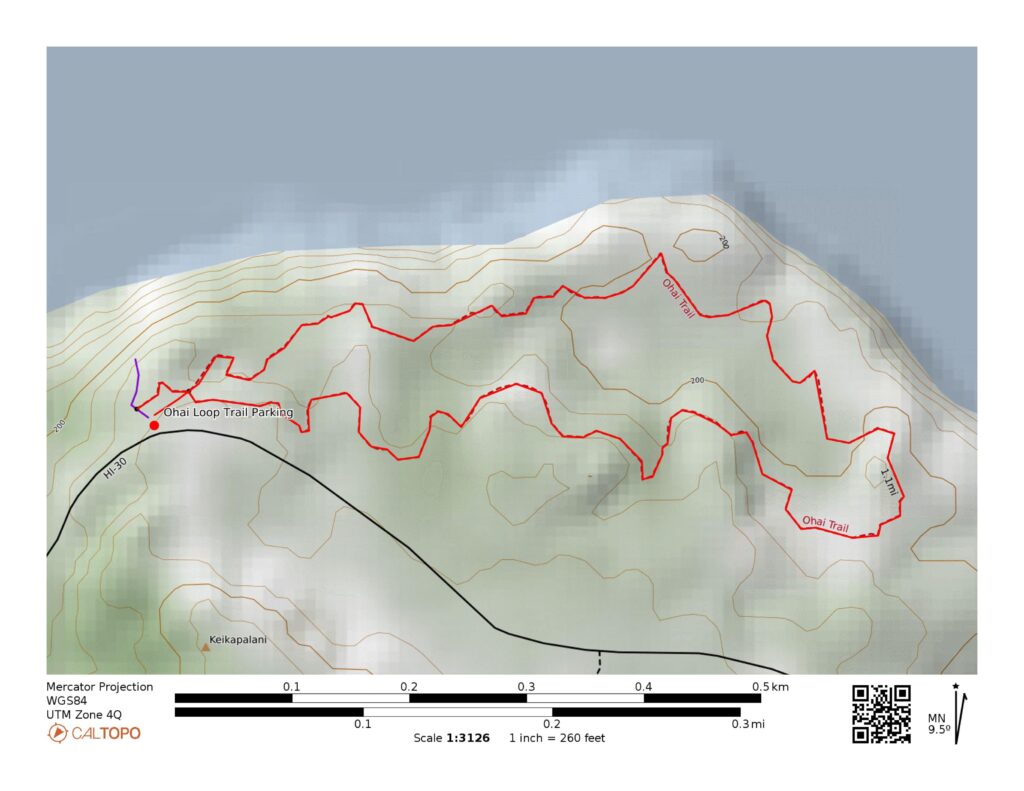
Complete Details of the Ohai Trail West Maui
We hiked the Ohai trail at the end of the day after spending the day driving up the west coast of Maui. We made stops in Lahaina, Kapalua, and at the Blowhole along the coast before stopping at the Ohai Trail. Our kids all walked out for the view right near the parking lot and then Dave and I did the short 1.2 mile hike.
After just one minute of walking, you will get to the fork in the trail. We chose to do the hike in a clockwise direction, but both options work. The trail begins be following the cliff edge (although it never gets too close to the edge). The trail is generally easy and flat with very few rocks until you reach each of the viewpoints.
The trail goes to several viewing areas on rocky outcrops. This stretch of the trail offers the best views of the rocky coast and pounding waves. The views here were some of our favorite on Maui. After following the coast for about 0.6 miles, the trail loops back around and begins to make it’s way back to the parking lot.
The trail in this section winds through some bushes, and you get an interesting view of several volcanic formations. This part of the trail is easy to follow fast walking. The entire trail took us about 40 minutes to hike including time to stop, take photos and admire the view.

Looking for other incredible things to do in Northwest Maui? Check out:

Nakalele Blowhole
This incredible and short hike is a must-do in Maui. Visit the blowhole and watch the water shoot high into the air.

How to Visit the Dragon’s Teeth Maui and the Kapalua Labyrinth on Stunning Makaluapuna Point
Explore the beautiful Dragon’s Teeth and Labyrinth.