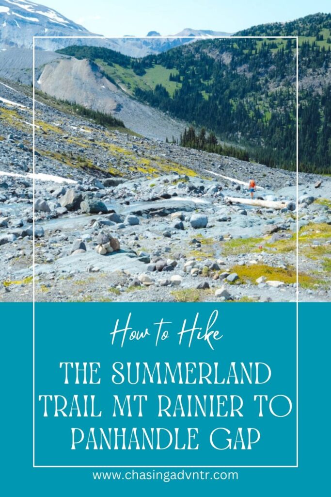

The hike up the the Summerland Trail Mt Rainier to Panhandle Gap is one of the most underated and beautiful hikes in the park. This trail has a little bit of everything from a lovely walk through the forest to fields of wildflowers and snow capper mountains.
Not only is the trail breathtaking, but it is also much less crowded than some of the more popular trails in Sunrise. We hiked the trail to Panhandle Gap in early July and while there were crowds on other trails and getting into the park, we saw only about 20 other people during the entire hike.
In this post you will find general information to help you plan your hike to Summerland and Panhandle Gap including where to park and what to expect on the trail.
Looking for more information about planning a trip to Mount Rainier National Park? Check out our Guide to Mount Rainier National Park.
Overview of the Summerland Trail Mt Rainier
Distance: 12 miles
Elevation Gain: 3,100 feet
Difficulty: challenging

Fee: This hike is within Mount Rainier NP and requires a fee to enter
Dogs: No dogs are allowed on the trail
Kids: Depending on the age of your kids, this is a great hiking trail.
This hiking trail is partly on the Wonderland Trail. This incredible trail is a 93 mile loop that circles Mount Rainier and is done over multiple days. Hiking the trail to Panhandle Gap gives you the chance to hike a portion of the Wonderland Trail.
There are several alternative options to consider when hiking this trail:
Hike to Summerland: If you want to get the mountain views but don’t want to go all the way to Pan Handle Gap, you can hike just to Summerland. This hike is about 8 miles round trip with just over 2,000 feet of elevation gain.
One Way Hike Summerland Trailhead to Ohanapecosh: Hadley, Finley and Dave were feeling really good on the day we did this hike and decided to continue over Panhandle Gap and hiked back to Ohanapecosh campground. This trail is about 20 mile in total distance and is a commitment and only works if you have a driver since this is a point to point trail.
Our National Parks are full of epic hikes, sweeping vistas, and amazing ecosystems.  If you like our parks, you'll love our National Parks Newsletter or you can explore exactly how we plan a National Parks Trip.

Visiting all 63 National Parks?  Join the Club.
Trail Description
Old Growth Forest
The trail to Summerland starts gradually through an old growth forest of evergreens. This is trail is very easy and pretty and wanders down a wide and easy path through the forest. You can cover some quick mileage on this section of the trail.

Fields and Valleys to Summerland
Once the trail climbs out of the forest it gets slight steeper and you begin getting views of Rainier. You will hike up a valley with a stream to your left and a steep hill to your right. There are several spots along some large switchbacks where you get views of the stream running below. The valley is very pretty and you will see Mount Rainier directly in front of you as you hike.
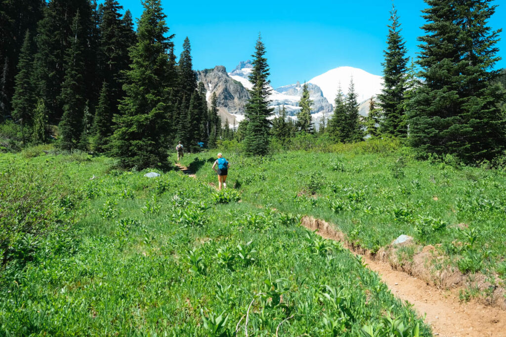
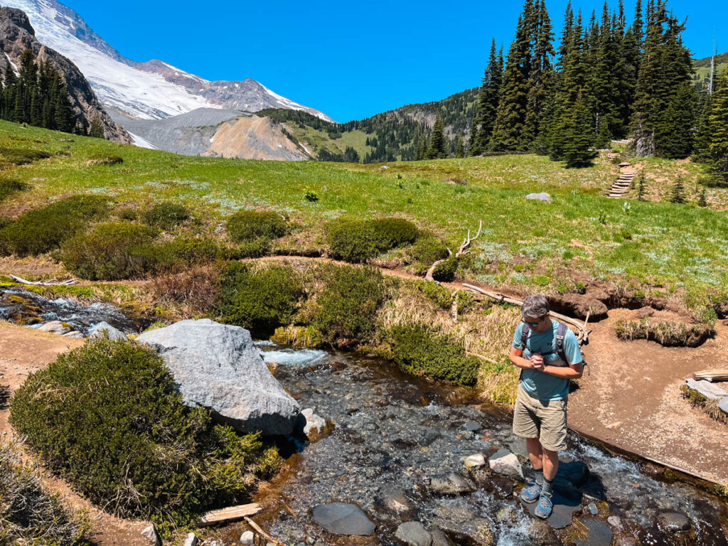
After a stream crossing, the trail ascends more steeply via some switchbacks before reaching the beautiful meadows of Summerland. This is the hardest part of the trail, but the path is easy footing.
You will find some basic facilities at Summerland including a toilet.
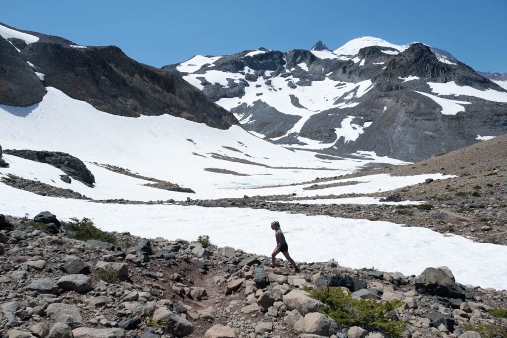
Summerland to Panhandle Gap
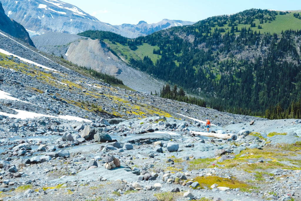
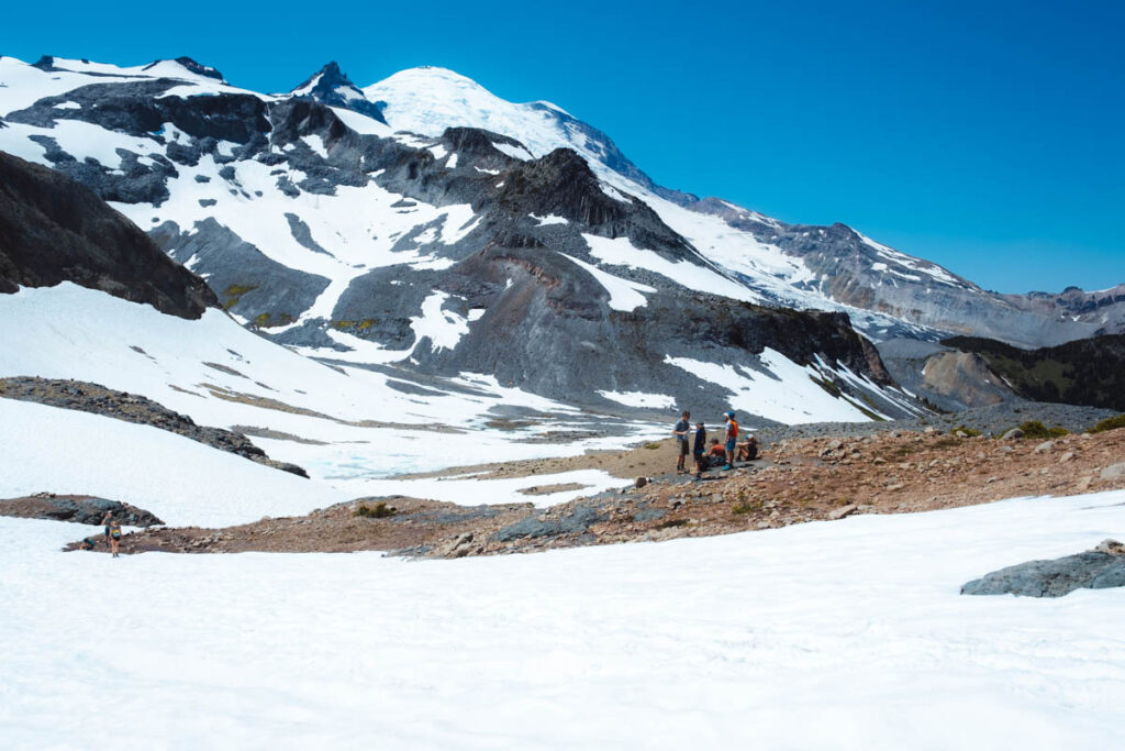
From Summerland the trail stays above tree level and passes through fields of flowers for a short distance before becoming more rocky with incredible views of the mountains. There are several stream crossings, some with log bridges and depending on the time of year, you may need to cross several snowfields to get to Panhandle Gap.
From Summerland to Panhandle Gap the trail is about 1.5 miles each way with 1,000 feet of elevation gain. In general, the trail gets steeper as you go along and teh footing gets more challenging.
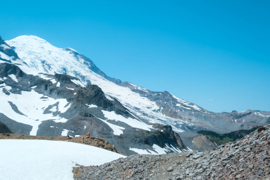
There is a small lake at the base of one of the cliffs that was mostly snow covered when we were there, but you can see some of the melting in the photo below.

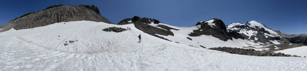
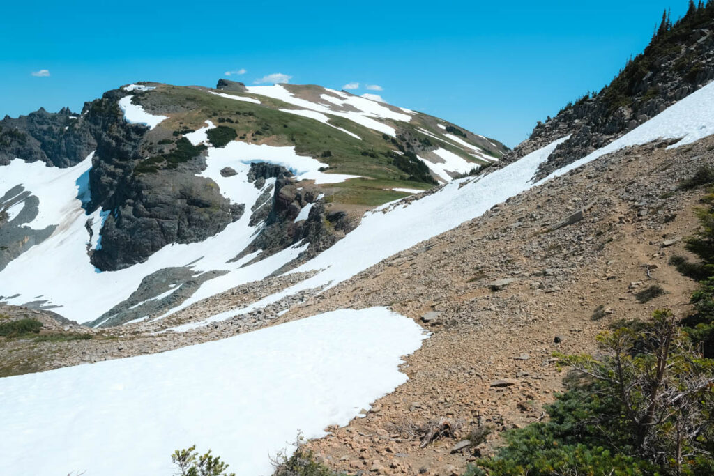
Just before getting to Panhandle Gap, you ascend to a smaller gap with a view. The snow conditions made this part of the walk comfortable, but the final push to Panhandle gap was a bit more challenging.
You will need to assess the snow conditions on the day you are there to decide whether it’s worth the final push to Panhandle Gap. (if you are concerned, the view from the first gap is just as good as the Panhandle Gap.
To get to Panhandle gap, you will traverse along the top of rocky slope partially covered in snow. We spent a while here sliding down on the snow for fun, but the further up you go the more challenging the slide becomes as there are exposed rocks below. We eventually decided to do the final climb up to the gap, but use caution.
Once you’ve enjoyed the views from Panhandle Gap, turn around and retrace your steps back to the parking lot.
How to Get to the Summerland Trail Parking Lot
The parking lot for the Summerland Trailhead is relatively small with room for maybe 20 cars. It’s best to arrive early to make sure you get a spot. We did this hike on July 3 and arrived by 7:30 and got one of the last spots along the road next to the parking lot.
The trailhead is along the way up to Sunrise and you will need to pass through the National Park gate to get to the parking lot. There is often a sign saying the lot is full, but since you won’t be going to the Sunrise parking area, this isn’t a concern.
If you are entering the Sunrise area, there is often traffic and we heard multiple stories of people waiting up to an hour just to get into the gate. Try to arrive early (before 8:00) to avoid the crowds.
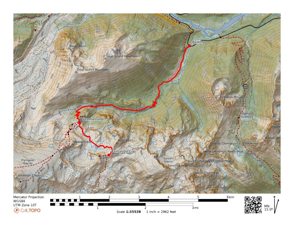
Map of the Summerland Trail Mt Rainier to Panhandle Gap
When to Hike the Summerland Trail Mt Rainier to Panhandle Gap
The trailhead to Summerland and Panhandle Gap starts around 4,000 feet and depending on when you are hiking you will likely come across significant snow. The road to Sunrise typically is only open from late June-October. Check on the NPS site to get updates on road openings.
This is the best time to do this hike and if you are hiking in mid summer you willl be walking through fields of wildflowers. During the summer months, you will also get bugs, so make sure to pack some bug spray.
Fall can be an amazing time to do this hike as the bugs subside a bit and the colors are lovely.

5 Things to Know for Hiking Summerland Trail Mt Rainier to Panhandle Gap
Start Your Hike Early
This is a good hike to start early (before 8:00). If you arrive much later than 7:30, there is a chance the parking lot will be full. Starting early also gives you the most options for this hike and you can enjoy an early lunch at Summerland before heading up to Panhandle Gap.
Mornings are often cloud covered on Rainier, so starting early will get you up into the higher region around mid-morning when the clouds typically burn off.
Leave No Trace
Always stay on the trail and pack out what you pack in.
The only toilet on this route is at Summerland, so plan accordingly.
Pack Plenty to Food and Water
This is a long hike and while there was plenty of water, you should bring your own clean water or plan on treating water as you go. We suggest at least 2 liters of water per person and plenty of snacks.
Wear Good Hiking Boots and Pack the Essentials
Due to the snow and stream crossings, it’s important to wear waterproof hiking boots. We all ended up with slightly wet feet on this hike, especially since we hiked on a warm day and the snow was very soft.
In addition to day hiking essentials, you may also want to consider:
- Hiking Poles (we found these helpful in the snow)
- Sunscreen
- Cell Phone for photos
- Microspikes (optional depending on the conditions)
Download a Map and Don’t Count on Cell Service
We had no cell service for most of this hike. While the trails are well marked in general, you should have some type of map with you. You can also download the map on All Trails or use maps.me.
More about Exploring US National Park and Travel?
Check out our National Park Planning Guides and see exactly how we plan a National Parks Trip.
If you’re exploring Washington, you might also like spending a few days in Olympic National Park.
Follow along with us as we try to complete our list of 100 Adventures or learn more about how we travel.