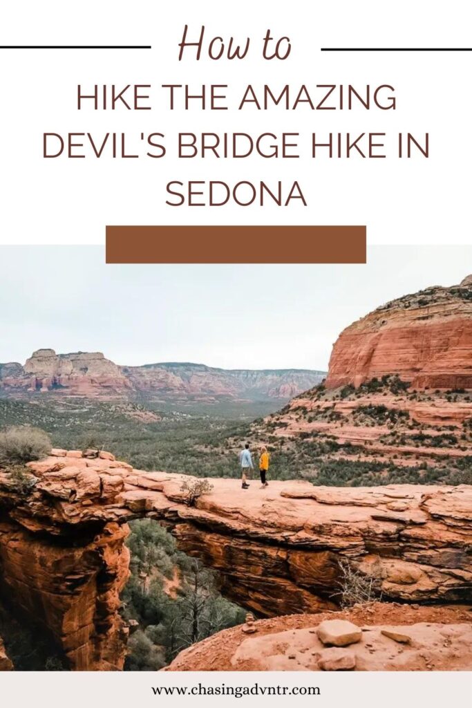

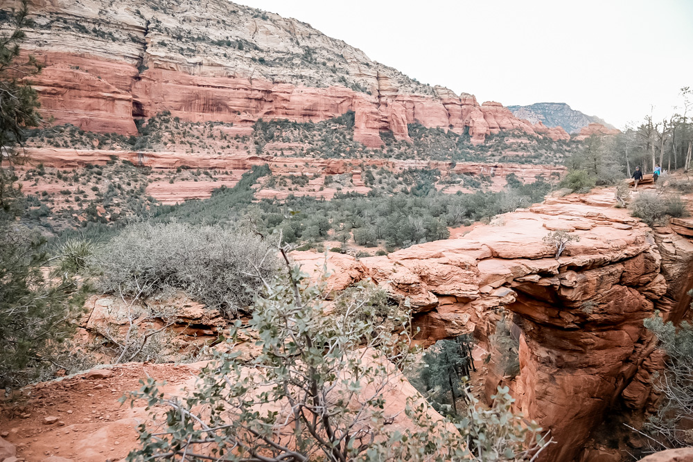
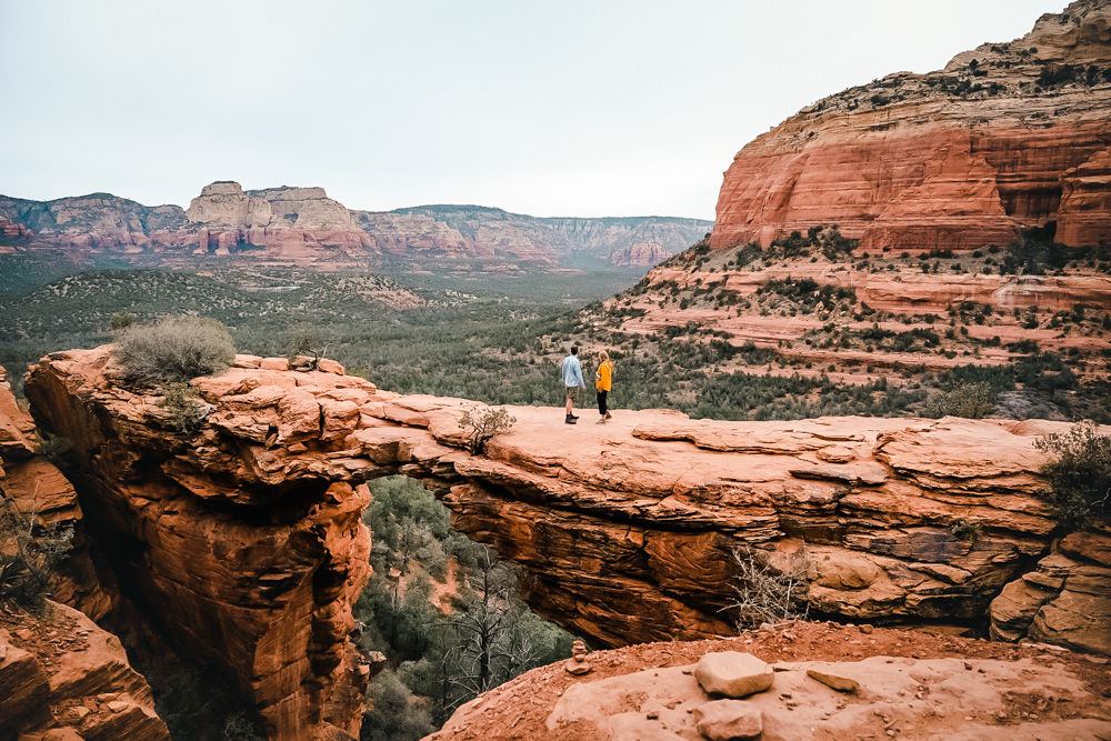
The Devil’s Bridge hike is one of the classic Sedona hikes and is a must-do if you’re visiting Sedona. The hike ends at the natural red rock bridge at the edge of a rock wall giving an epic photo destination with the valley in the background. Starting early in the morning people line up to walk out onto the largest rock bridge in Sedona to snap the perfect photo.
We hiked the Sedona Devils Bridge Trail in late March of 2022 and even though we started hiking in the dark there were plenty of people with us on the trail. Make sure you get started early on this popular hike in Sedona.
Read below for the details on the best way to hike to the Devil’s Bridge, including details on the Devil’s Bridge trail parking and how to make the most of the trail, manage the crowds and enjoy the Devils Bridge Sedona.
I’ve spent decades exploring family adventures, epic hikes, and National Parks across the world. For more inspiration, check out my National Parks Page or see some of my favorite destinations to plan your next adventure and make sure to join my weekly newsletter.
Quick Overview of the Devil’s Bridge Hike Sedona
There are three ways to hike to Devil’s Bridge in Sedona. All of the hikes are relatively easy. The first part of all three hikes begins on a wide mostly flat trail with a steeper climb up some rock steps to the final ledge next to the bridge.
Parking at the End of Dry Creek Rd.
The first way to get to Devil’s Bridge is to drive to the end of Dry Creek Rd. The last mile of Dry Creek Rd is unpaved and requires a 4×4, high clearance vehicle. Don’t try to drive this road without the right vehicle as there are lots of rocks and obstacle that truly requires high clearance. If you are hiking the trail from this parking lot, it is a 2-mile hike.
Parking at Dry Creek Vista Parking Lot
The second option if you don’t have a 4×4, high clearance vehicle, is to park at the Dry Creek Vista Trail Parking lot which is on Dry Creek Rd before it becomes a 4×4. From here you will walk down the unpaved section of Dry Creek Road. Since this is the same road where people are driving to the trailhead via 4×4, you will have a dusty walk on an unattractive road. Despite this, many people choose to hike to Devil’s Bridge this way and you will see cars lined up and down the road. From this starting point, the trail is about 4.6 miles depending on exactly where you park.

Parking and Hiking to Devil’s Bridge Via the Mescal Trail
In our opinion, this is the best way to hike to Devil’s Bridge Sedona. From the Mescal Trailhead, the hike is 4 miles and is a truly lovely walk that ends at the iconic red rock bridge. The hike starts on the Mescal Trail and turns onto the Chuckwagon Trail (which is also a mountain biking trail). This trail takes you directly to the start of the Devil’s Bridge hike (the same place you would go if you were hiking from the Devil’s Bridge Trailhead). From here it is just a mile to the bridge.
The rest of this guide will describe how to do the hike via the Mescal Trailhead as this is how we hiked the trail and we believe it is the best option.
Distance: 4 miles (2-3 hours with time for photos)
Elevation Gain: 520 feet
Difficulty: Moderate - some climbing at the end
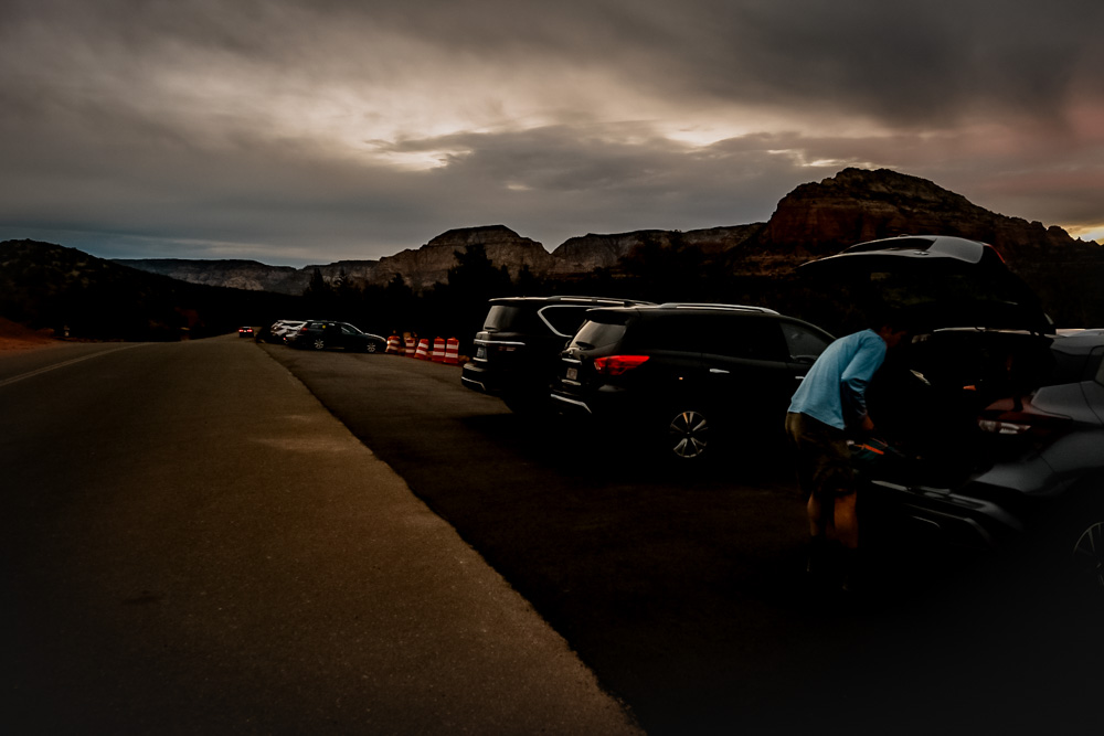
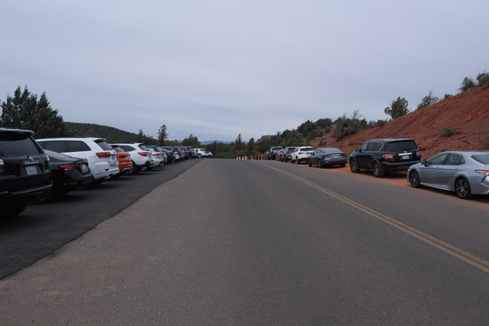
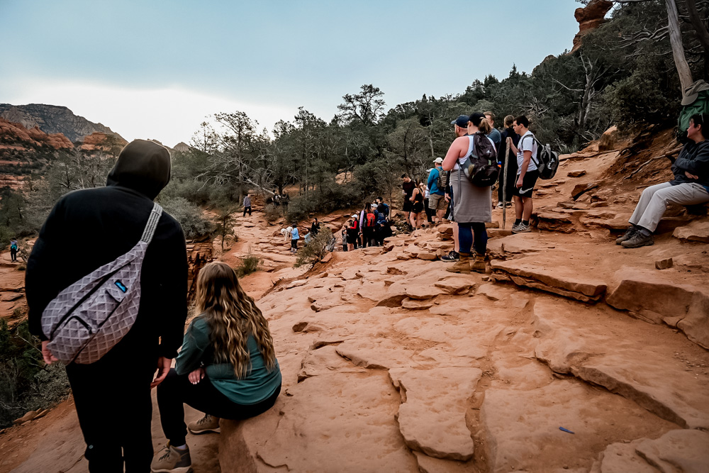
No matter which direction you decide to hike this trail, make sure you get to the trailhead early. Parking lots tend to fill up by 7 am and there can be a line at the top waiting to take photos on the famous Sedona natural bridge.
The Sedona Shuttle does not serve this parking lot.
Looking for the perfect long weekend in Sedona? Check out the Perfect 3-Day Sedona Itinerary or 11 Things to do in Sedona
Getting to the Mescal Trailhead
The Mescal Trailhead is located on Long Canyon Rd. about 12 minutes outside of Sedona. From town, take 89a west. Take a right onto Dry Creek Rd. You will drive past the other parking lots to access the trail, but continue onto Boynton Pass Rd and turn right onto Long Canyon Rd. The Mescal Trailhead is directly on the road.
We arrived at the trailhead around 6:15 am and there were still several parking spots. By the time we completed the hike, the lot was filled and there were cars parked up and down the road.
Things to Know About Hiking to Devil’s Bridge, Arizona
Before you head off on the trail, there are a few things you need to know about this hike.
Parking Pass: You will need a parking pass to park at the Mescal Trailhead. The Red Rocks Pass is $5/day or $15/month and can be purchased at the trailhead. A National Parks Pass also works for parking.
Best Time to Hike to Devil’s Bridge, AZ: The best time to hike in Sedona is spring and fall when the weather is comfortable, but these are also popular times on the trail. Summer is very hot in Sedona. There is very little shade on the Devil’s Bridge Trail so if you are hiking during the hot season, make sure to bring lots of water and get an early start.
Map of the Devils Bridge Hike Sedona
Hiking the Devils Bridge Trail
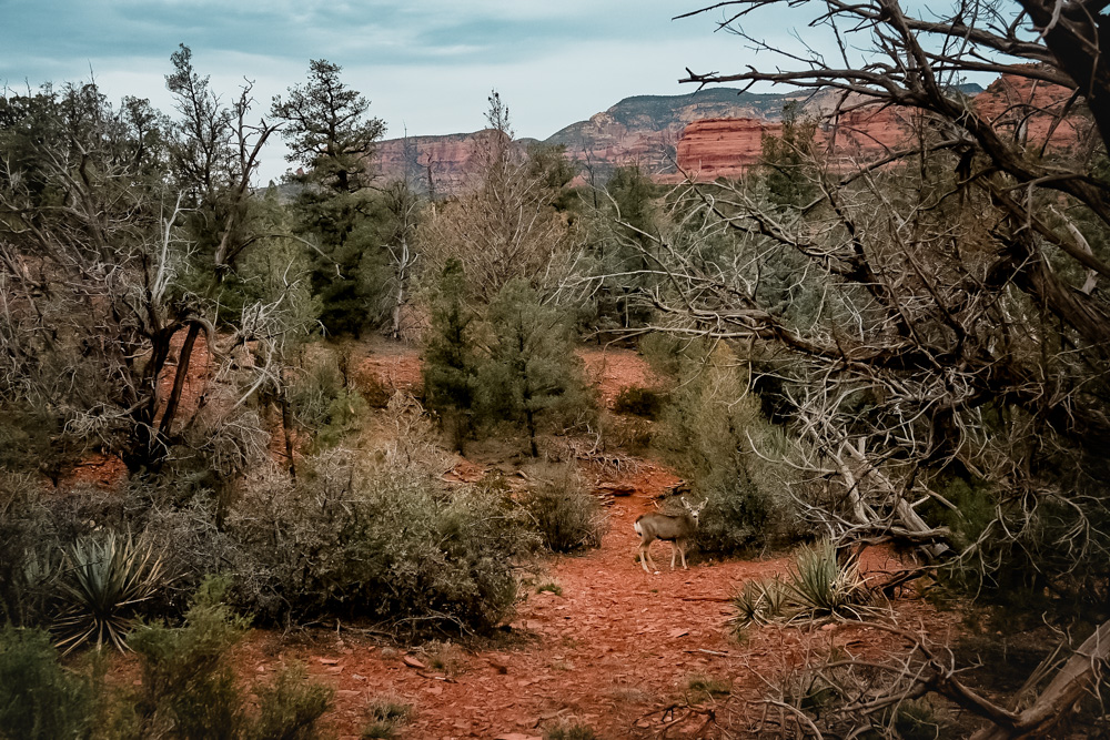
Leave the Mescal Trailhead on the Mescal Trail. The start of this hike is on a narrow trail that leads through classic desert scenery with views in the distance of the red rock walls rising from the canyon floor. The trail is mostly flat and very easy to follow.
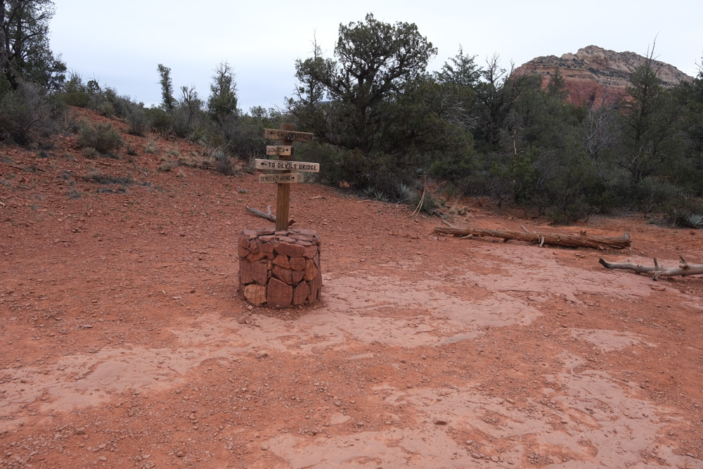
After a short distance, the trail intersects with the Chuckwagon Trail. This is also a Mountain Biking trail, so be on the lookout for bikers and step aside so they can pass. The trail is well marked, but you will bear to the left at this sign towards Devil’s Bridge.
After just about 1 mile, the trail comes to the intersection of Dry Creek Rd. You will see the road in the distance during the hike. Since many people come in on this road, you will find it much more crowded. We saw just a few people on the Mescal and Chuckwagon Trails, but once we joined up with the Devil’s Bridge Trail, we were hiking along with several other people.
From here, the trail becomes wide and well packed and begins to climb slightly towards the canyon wall. When you get to the base of the rock wall to the bridge, the trail becomes steeper and begins to climb. Most of the elevation gain is in just the last few hundred feet. The trail first winds upward and eventually becomes stairs that have been carved into the rock.
There are a few places to stop for views or breaks along the way. Because several places can only be hiked one person at a time, there are a few bottlenecks where you may need to wait for people to pass.
After the last set of stairs, you will find yourself on the ledge next to the bridge. This is a large area where people wait for a turn to walk out on the bridge for a photo. You can easily snap your photos from here between people going out and there is a tremendous view with the Devil’s Bridge in the foreground and the canyon walls in the background.


We arrived at the bridge just after 7 am and the line was just starting to form. We had to wait just a few minutes, but even by the time we left, the line was longer. The bridge is nice and wide when you’re on it and not nearly as scary as it appears from the side, although if you have any fear of heights you may want to avoid going out on the bridge.
While we felt completely comfortable on the bridge itself, watching other people go out, run and climb around on the bridge was a bit nerve-wracking.
What to Pack for the Devils Bridge Sedona Hike
Depending on the time of year, daytime temperatures can be hot while early morning can be quite cool. It is best to pack in layers and pack plenty of water even for short hikes. Below is a list of what we packed and wore when hiking in Sedona:
- Hot Weather Hiking t-shirt
- Long Sleeved Layer
- Shorts
- Socks
- Hiking Boots/shoes
- 2 Liters of water
- Snacks
- Basic First Aid Kit
Common Questions About Devil’s Bridge, Sedona
Is it worth hiking to Devil’s Bridge? The quick answer is yes. The trail is wildly popular but the view from the top really is stellar.
Is the Devil’s Bridge hike easy? The first portion of the hike is easy, but don’t underestimate the climb up to the bridge. If you are in decent shape, you will have no problem, but the footing is difficult and we saw a few people turning around here before they got to the top.
Can you drive a 4×4 to the top of Devil’s Bridge? No – you can drive to the Devil’s Bridge Trailhead and walk the last mile.
Is the Devil’s Bridge hike dangerous? There have been injuries and even deaths on the Devil’s Bridge hike. Use common sense and caution when hiking here.
Can you bike to Devil’s Bridge? While there is mountain biking on some of the trails (such as the Chuckwagon Trail) you can’t bike the final portion up to the Natural Bridge itself.

Looking for other great hikes in Sedona? Check out the Best Hikes in Sedona, or you might also like:
- Boynton Canyon (Subway Cave)
- Birthing Cave
- Hiking the Brins Mesa and Soldier’s Pass Loop
- The Broken Arrow Trail